After yesterday’s successful and sunny climbs of Pico de Orhy and Arthanolatze, I was looking forward to another easy day in the mountains on 31st August 2022 but it was somewhat more difficult.
Urkulu EA2/NV-022
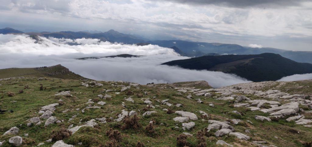
Overnight, there had been a substantial thunderstorm with rain in the Pyrenees and the drive into the valley from St. Jean Pied de Port was rather wet. My first problem was that I only had an underpowered Fiat Panda for my hire car, and on the slippery roads which had just seen their first substantial rain for months, there was no way I could get up the tiny steep roads from the D933 at Arnéguy that my sat nav wanted to take me on. After several false starts, I made it back to St. Jean Pied de Port and onto the much better D428. This back-tracking already made me substantially behind schedule, but as I climbed, the low cloud and rain turned, of course into fog. The reduced visibility in itself would have been bad enough but this was compounded by the fact that the D428 forms part of the Compostela pilgrimage route and my route was packed with pilgrims walking in the middle of the road, even on the hairpin mountain bends, with little to no visibility. By the time I reached the Refuge Orisson, on the way towards Urkulu, I decided that the drive had become too dangerous for me to be comfortable, and I pulled in for a while to see if the fog would lift. It didn’t. After 30 minutes pulled in, and still surrounded by pedestrians, I took advantage of a brief spell of extra visibility to continue uphill, hoping that I would eventually break out of the fog. Luckily, my hope was correct and a couple of kilometers further on, I found myself able to see again.
Eventually, I made it to the car park at the foot of Urkulu. Like Ori yesterday, the car park itself is on the border with Spain, but unlike Ori, there is no way to cross the border by car as the D428 continues on the French side.
It was in this car park that I had my next problem. A herd of horses took a strong interest in my hire car and started licking it and one even tried to sit on the bonnet. Luckily I was still in the car at this point and reverse gear was swiftly engaged before any damage was done, but I certainly left the car with some unease about the state I would find it in on my return!
As I started climbing Urkulu, the fog had caught up with me and started to envelop the road I had just driven up.

The walk up Urkulu itself is pretty much trivial. It isn’t very steep and it is directly uphill. This was very welcome given the likelihood that I might have had to descend with no visual aids!
Once at the top, you are rewarded with the Roman fort that Urkulu is famous for, believed to date back to the year 28 BC. Apparently there are views from here over the whole of the Aquitaine plain but I’ll need a future return visit to confirm that.

The summit is only a few tens of metres further on from the fort and has ample space for antennas, although it is quite rocky.
Urkulu is a 6-point summit for SOTA purposes, and I was able to make some 18 QSOs from here (all but one on 20m CW). I would have made more but, in the middle of the pile-up I started to hear thunder not too far away. Not wishing to be caught on a mountain in a thunderstorm with an antenna and with cloud hindering my ability to descend, I decided that a quick evacuation would be required.
Fortunately, I reached the car safe and sound and the horses seemed to have lost interest in the vehicle too, which was undamaged. Visibility was only about 20m though, so the decent down the mountain was very slow and was made additionally dangerous by a very stubborn horse that decided to stand right across the single-track road on a hairpin bend. Only after five minutes of revving the car engine did I eventually persuade it to move.
I had, by the way, hoped to climb Txangoamendi EA2/NV-170 at the same time as Urkulu since both routes start from the same car park but with the delays and inclement weather I didn’t have time.
As I said, the climb up Urkulu is fairly gentle: it’s only 200m ascent in 800m of walk. It probably took about 30 minutes to walk up (although I didn’t start my GPS until I was part of the way up the hill, as there were lots of other things on my mind!) and about 20 minutes to walk back down.
Total climbing: 190 m
Total time: 01:29:43
Mont Arrokagaray F/PO-251
Mont Arrokagaray is a small one-point hill in the Pyreneean foothills near Cambo-les-Bains, on the way back from Urkulu heading towards the coast at Biarritz. As a much smaller hill out of the mountains, it was unaffected by the fog I had on Urkulu, and the rain had stopped by now also.
I parked at the start of the track at 43.316°, -1.379°, which is not where I’d actually planned to park. This initially took me down what turned out to be a private driveway before I corrected that, so if you repeat this route you want to head north-east from the road as you will be going back behind the hill.
The only really notable thing to say about the climb is that a sign (in French and Basque) at the start of the path requested walkers not to climb the hill 8th May – 31st July or 1st September – 30th November. This was due to a scientific study to capture and tag the local vulture population. Luckily, today was 31st August so it was the last opportunity to climb the hill before the winter!

The path itself is a gentle grass track with pretty views over the local Basque countryside. The summit has a rounded top and the activation area is very large. Conscious of the local flora and fauna, I was careful to try to avoid setting up my aerial off the path, so I went a bit beyond the summit itself to set up in a slightly more open clearing. Luckily, there was absolutely no-one else around, so I wasn’t in anyone’s way.

This was a lovely spot to operate from and I was able to make 19 QSOs without having to descend in any hurry. Again, all but one of these was on 20m CW. I must take this opportunity to thank Christian F4WBN who made a QSO with me on 2m FM from every one of the four summits I activated, and who was clearly watching me on APRS as he was already ready to call me as soon as I reached the top! Christian is a well-known SOTA chaser who lives nearby in Bayonne.
The climb (once I went the right way) took me about 20 minutes and the descent took about 15 minutes.
Total climbing: 200 m
Total time: 01:49:03


